About our maps
This website is designed to help you find locations, and get around The University of Melbourne campuses.
Finding places
You can find maps using Google, or the University Search. All buildings are indexed for searching. It's the easiest way of quickly finding a location.
You can also come to the maps home page, and browse to a location. You'll see the menus follow a logical structure of Campus > Building > Location, that makes searching, and browsing as easy as possible.
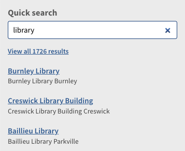
Quick search
Use the Quick Search tool in the top left corner of most pages to find items within the map. Just start typing into the search field to reveal locations, and select one to view it on the map.
Deeper searching
Quick Search only returns the top 5 results, so if you need more you can either type return, or click the link to view all results and visit the search page. This page is a more advanced search, that you can filter by campus and click through result pages 10 at a time.
Browse the map
You can browse the map. Click, zoom, and drag to find locations. Use the level bar to switch to a different floor, and click on a location to reveal a pop-up that displays any known information about the location.
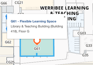
The title of the pop-up is a link to a single page view of the clicked location. If it's in the database, it will display detailed information, otherwise, it will use latitude and longitude only. You can use this page to share, and embed, any location with others.
Finding your location
Seeing where you are works just like Google, Apple, or any other maps. Clicking the target icon on the right side of the map shows, your location closely as possible.
If you are connected to UniWireless, this should be faster, and more accurate. If you're indoors, it can even switch the floor level of the map to the one you're currently on.
Getting directions
You can get directions from any location page. You can use your own location, or another found location as the start or end point. MazeMap directions include details within buildings, and floors.
Once directions are displayed, you can reverse them, and you can choose to 'avoid obstacles' - avoiding stairs and other barriers.
If you prefer to get your directions from Google Maps, Open Street Map, or Apple, there are links in the Sharing Options.
The data
For those who are interested, the map you are looking at pulls data together from many different sources.
- The base map is from OpenStreetMap.org rendered by MapBox.
- The buildings overlay comes from MazeMap, based on data drawn from the University's own building management system.
- Directions are provided by MazeMap based on data provided by the University within buildings, and OpenStreetMap outside buildings.
- Some pages include photographs owned by the University.
So, it's complicated!
If you do find problems let us know by submitting feedback, or by raising a helpdesk ticket online, or by calling +40888.